CROSS Harmonization & HPC modelization of FOREST Datasets
DATA
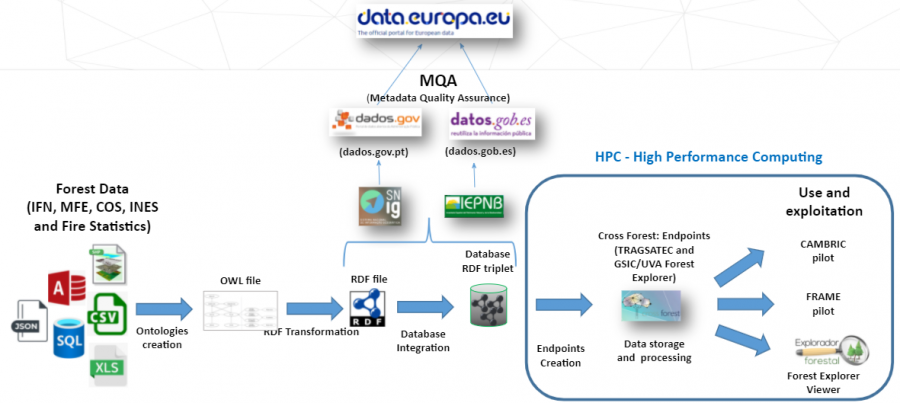
The different modules of the ontologies and datasets are published separately, to allow the potential users to select which modules they want to use. All data is either already published or will be published under CC BY 4.0 License. They can be currently accessed at https://github.com/Cross-Forest/Data

- IFI (Iberian Forest Inventory) data contains information about dominant formations aggregated by NUTS2 or NUTS3, derived from national forest inventories (Spanish IFN version 3 and Portuguese version 6). It is a Microsoft Access database in a proprietary format (accdb). It is publicly available at https://github.com/Cross-Forest/Data/tree/master/ifi.
- IFN3 (Third National Forest Inventory, Spain) data contains sampling information about trees and shrubs in the Spanish territory. It is updated with a periodicity of 10 years, although at present, it takes around 15 years to complete an update for economic and social causes. Currently, data for the 4th update is being gathered, so the 3rd version of the inventory (IFN3) is the focus of the transformation into RDF. The data of IFN3 is split in 100 files (two for each province of the Spanish territory). These files are published in zipped SQL databases, with an ad-hoc schema, and in a proprietary format (Microsoft Access). It is publicly available at https://github.com/Cross-Forest/Data/tree/master/ifn and at https://datos.gob.es/catalogo/e05068001-inventario-forestal-nacional-ifn-iii.
- IFN6 (Sixth National Forest Inventory, Portugal) data is included in the previous IFI dataset. data is included in the previous IFI dataset. IFN is a process of statistical and cartographic nature, which aims to assess the abundance, state and condition of national forest resources. At IFN, the production of statistics is based on sampling processes, which are carried out in different stages that make up the global task of Inventory. In Continental Portugal, the IFN started in 1965 and, since that date, it has been maintained permanently with a periodicity of about 10 years.It is publicly available at https://github.com/Cross-Forest/Data/tree/master/ifi and at https://dados.gov.pt/pt/datasets/6o-inventario-florestal-nacional-ifn6-rdf-projeto-cross-forest-6th-national-forest-inventory-ifn6-rdf-cross-forest-project/
- MFE50 (Spanish Forest Map, 1:50.000) data contains cartographical information about the spatial distribution of forest land, described using polygons over the Spanish territory. In a similar fashion to the IFN, MFE is updated with a planned periodicity of 10 years, although at present, it takes around 15 years to complete an update for economic and social causes. Currently, the 3rd version of the MFE (MFE25, with a scale of 1:25000) is in the final stages of being collected. As a result, the second version of the MFE (MFE50) is the dataset that has been transformed into RDF in Cross-Forest. MFE50 is split in 50 zipped GIS shape files (one for each province of the Spanish territory), where each patch is characterized by a polygon. It is publicly available at https://github.com/Cross-Forest/Data/tree/master/mfe and at https://datos.gob.es/es/catalogo/e05068001-mapa-forestal-de-espana-escala-1-50-000.
- COS2018 (Land Occupation Cartography, Portugal) data contains cartographical information about land cover and use. COS is a map of polygons with a defined minimum cartographic unit (1 ha) with a distance between lines equal to or greater than 20 m. COS is based on photointerpretation and has a nomenclature with more than 80 classes. There are five versions of this dataset (1995, 2007, 2010, 2015 and 2018) that are delivered by a unique GIS shape file for Portugal mainland. It is publicly available at https://github.com/Cross-Forest/Data/tree/master/cos at https://dados.gov.pt/pt/datasets/carta-de-uso-e-ocupacao-do-solo-cos-2018-rdf-projeto-cross-forest-land-use-land-cover-map-cos-2018-rdf-cross-forest-project/
- INES (National Soil Erosion Inventory, Spain) data contains homogeneous geographic information of five types of erosion during the period 2002-2019. The work scale is 1:50.000 and all the lands are included (forests, grasslands and croplands). The data of each type of erosion is split in GIS format (vectorial or raster) for each province of the Spanish territory. Three of the five types of erosion have been transformed into RDF in Cross-Forest. It is publicly available at https://datos.gob.es/catalogo/e05068001-inventario-nacional-de-erosion-de-suelos-ines
- IBERIAN FOREST FIRES STATISTICS contains information about the forest fires recorded in Spain (1983-2015) and in Portugal (1980-2015) with specific data such as year, municipality, cause and burned area. Positions of forest fires begin to be recorded from 2005 in Spain and 2001 in Portugal. These statistics are in excel format and have been transformed into RDF in Cross-Forest. It is publicly available at https://datos.gob.es/catalogo/e05068001-estadistica-general-de-incendios-forestales and at https://dados.gov.pt/pt/datasets/estatisticas-de-incendios-florestais-portugal-rdf-projeto-cross-forest-statistics-of-forest-fires-portugal-rdf-cross-forest-project/
SPARQL endpoints make available the content of the Core, Alignment, and Grid Modules. The SPARQL endpoint for forestry data can be currently accessed at https://forestexplorer.gsic.uva.es/sparql.
Details of the data exportation, publication and management plan can be checked in the deliverables D2.3 and D2.4 available below for access.
